Digitrail hiking trails
Evo, Evo Centre
Evo is well-known for the first forestry institute in Finland, as well as its wilderness, nature, birds and beavers. The Evo Hiking Area (approximately 4700 hectares) has been popular amongst hikers as well as scouts for decades. Lynx trails criss-cross the area, which provides hiking trails tailored for every taste, all the way to Asikkala and Padasjoki.
Evo is located higher than its surroundings in a watershed region, which is characterised by plentiful small lakes and ponds, and soil with low nutrient value. Traditional forestry has directed the development of Evo’s nature. The dominant forest types are mesic and sub-xeric heath forests. The pine is the most common tree species, and more than half of the trees are pine trees. There are only few lush areas in Evo. Also natural mires are rare. You can see mires, for instance, along the Lake Niemisjärvi trail or Harjupolku path. The undulating landscape was formed by the Ice Age.
There is much to see and experience along Evo’s hiking routes. The water bodies are clean, and you can even drink directly from some of the lakes. A lucky visitor may even spot a beaver constructing a dam. Fishermen and families with children enjoy fishing the implanted or natural salmon. Evo Centre offers café and accommodation services almost throughout the year, and the campus saunas (a traditional and a smoke sauna) can be hired for recreational purposes. Additionally, there are lean-to shelters, cabin accommodation, and campfire sites in the area. Experience the energy of Evo any time of the year.
Evo-trails
Theme of the trail: Forest assesment tasks
Trail description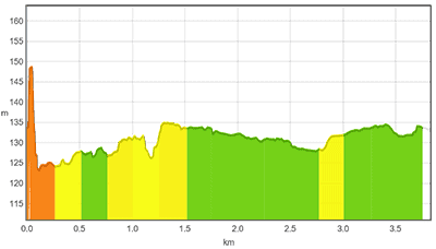
The easy (approximately 3.8 km), blue route departs from the Evo Centre and follows the Metsätaitorata Trail of the campus almost from beginning to end. In addition to hiking, you can test your own forest skills along the track, as presented by the mobile app. The trail goes around Lake Alinen Rautjärvi, with the scenery changing rapidly from a young pine forest to a recently planted one. The trail then crosses over River Luutajoki and finally disappears into a spruce forest. In the spruce forest, you can see historical charcoal pits, and continue your journey into an old pine forest. The Onkimankangas campfire site on the western side of Lake Alinen Rautjärvi is a great place for resting, as it offers beautiful lake views. The route continues onto a road south of Lake Alinen Rautjärvi, and returns back to the Evo Centre, passing by the football field and Evo’s sawmill.
Good to know
The route is its own entity, and it is difficult to connect it seamlessly with other trails in Evo. However, the terrain is easy and the route is clear to follow. In addition, at the beginning of the route it is possible to go for a swim in Lake Rautjärvi. Apart from its last third, the trail follows a path or a carriage road, and is not lit. It is also possible to ride a bike on the trail. The trail has one campfire site with an outdoor toilet nearby. The Evo Centre café located at the trail’s start and end is open on weekdays from 8 to 14.
Level of difficulty
The trail takes approximately 1.5 hours. At the beginning, the trail follows a path with an even surface, and widens towards the end into a forest motor road and eventually a surfaced road. The route may be wet in rainy weather, but otherwise it does not offer any great challenges. The trail is not lit, and so it makes sense to hike in daylight. Regular outdoor equipment suffices, taking into account the weather.
To the start of the trail
The trails start from the Evo Centre, which can be accessed from the main road number 53 by following the signs to Evo or Häme University of Applied Sciences. There is plenty of parking space in the Evo Centre area. The trail’s starting point is approximately 20 kilometres towards Padasjoki from Shopping Centre Tuulonen, and approximately 25 km from Padasjoki towards Tuulonen.
TRAIL’S START AND END POINT: : Evo Centre, Saarelantie 1, 16970 Evo 61.196849, 25.107987
TRAIL MARKINGS: There are no route markings along the trail, but the path is easy to follow with the DigiTrail app.
TRAIL SUITABILITY: : The trail is suitable for all hikers, both children and adults. The terrain is easy to walk on.
Theme of the trail: Forest Yoga
Trail description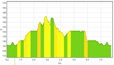
The intermediate (approx. 7.8 km), red route departs from the Evo Centre along a sawdust track, follows the Syrjänalusen Harjupolku Trail, and returns along the sawdust track and forest paths back to the Evo Centre. There is a lot to see along the way, and Evo’s nature shows its true potential: in addition to varying terrain and old burning pits, there are natural water bodies along the way, offering clean drinking water. At the beginning of the trail, you can climb to the top of Punssivuori Hill, which offers a beautiful view over Evo. The route continues along a sawdust path to Syrjänalunen, where the Harjupolku Trail starts, returning eventually back to the road. After crossing the road, you can walk along duckboards which go around the mire nearby. The duckboards are old and, in a couple of places, your feet may get wet. After the swamp, there is a small spring along the trail. The route continues from the spring to the end of the Harjupolku Trail, returning back to the Evo Centre along a sawdust track and paths.
Good to know
The route runs along Hämeen Ilvesreitistö (Häme Lynx Trails), and can be easily tailored to your needs. Its is easy to connect the intermediate trail with Evo’s difficult (black) route, which heads to the Sorsakolu lean-to shelter. A sign in the northern end of the esker guides the visitors directly to Sorsakolu. The sections along the sawdust track are illuminated. There is a lean-to shelter, a campfire site and an outdoor toilet by Lake Syrjänalunen. The Evo Centre café located at the trail’s start and end is open on weekdays from 8 to 14.
Level of difficulty
The trail takes approximately 3 hours. It is a good idea to wear waterproof shoes along the route. Otherwise, regular outdoor equipment suffices, taking into account the weather.
To the start of the trail
The trails start from the Evo Centre, which can be accessed from the main road number 53 by following the signs to Evo or Häme University of Applied Sciences. There is plenty of parking space in the Evo Centre area. The trail’s starting point is approximately 20 kilometres towards Padasjoki from Shopping Centre Tuulonen, and approximately 25 km from Padasjoki towards Tuulonen.
TRAIL’S START AND END POINT: : Evo Centre, Saarelantie 1, 16970 Evo 61.196849, 25.107987
TRAIL MARKINGS: : The trail contains route markings for the Ilves- (Lynx) and Harjupolku Trails. In addition, the trail is easy to follow using the DigiTrail app.
TRAIL SUITABILITY: : The route is suitable for slightly more advanced hikers.
Trail description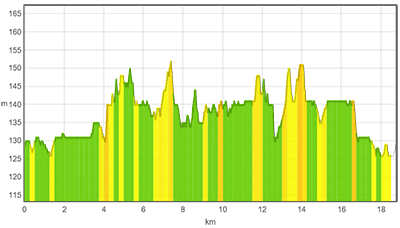
The difficult (approximately 18.8 km), black route starts from the Evo Centre in a similar way to the other routes. It passes through the teaching forest, follows, to a great extent, Ilvesreitti (Lynx Trail) to the Sorsakolu lean-to shelter, and back to the Evo Centre. The trail heads to the north along Ilvesreitti (Lynx Trail) through the campsite of Pitkänniemenkangas, where the trail continues along the western side of Lake Pitkänniemenjärvi towards a lean-to shelter in the north, which is a good place for a little pause. From the lean-to shelter, the trail continues along a road for a while, until it joins a forest path and passes the former Fisheries Research Institute. The route then continues along a road, crossing over the slightly bigger Talvilammentie Road. From Pukkivuorentie Road, the trail turns west along a path towards the shore of Lake Rahtijärvi, and continues as particularly rocky along the shore between Lake Rahtijärvi and Lake Savijärvi. It passes the old ironworks, of which only a few foundation stones remain to our days. From the ironworks, the route continues along the shore of Lake Savijärvi, turning into a narrow strip between the shore and a steep cliff, and sometimes leading deeper into the forest. Halfway through the route, the Sorsakolu lean-to shelter is located at the very nothernmost tip of Lake Savijärvi. From there, it is possible to continue along the Evo route or lengthen the hike by heading towards Ilves-reitistö (Lynx Trails) in Padasjoki and Asikkala. From Sorsakolu, the route continues back towards the Evo Centre, going around Lake Savijärvi and returning to the same path between Savijärvi and Rahtijärvi. After passing the former Fisheries Research Institute, the route climbs up Peikkovuoren harju (the Goblin Ridge) and runs from there to the Syrjänalunen lean-to shelter, passing by Hautjärvi Grove and Karvalammi Spring (where you can fill your water bottles) along the way. From Syrjänalunen, the trail continues towards the Evo Centre mostly along a skiing path.
Good to know
The route joins together the trails of Evo and Päijät-Häme, which enables the planning of a few days’ hike from the Evo area towards Padasjoki and Asikkala. There are a lot of beavers in the Evo area, as a result of which the water level may be partly elevated and cover the duckboards. The section between Lake Savijärvi and Lake Rahtijärvi is rocky, wet and potentially slippery. Water bottles can be filled in the Evo Centre, from wells at Evo’s camping areas and from the spring located along the shore of Lake Karvalammi. There are several lean-to shelters and campfire sites with outside toilets along the route. The Evo Centre café located at the trail’s start and end is open on weekdays from 8 to 14.
Level of difficulty
The trail takes approximately 6 hours. The path is difficult in places, rocky or wet, and you should be careful in the challenging areas. It is a good idea to wear waterproof shoes along the route. Otherwise, regular outdoor equipment suffices, taking into account the weather. It is also a good idea to pack some snacks for breaks.
To the start of the trail
The trails start from the Evo Centre, which can be accessed from the main road number 53 by following the signs to Evo or Häme University of Applied Sciences. There is plenty of parking space in the Evo Centre area. The trail’s starting point is approximately 20 kilometres towards Padasjoki from Shopping Centre Tuulonen, and approximately 25 km from Padasjoki towards Tuulonen.
TRAIL’S START AND END POINT: : Evo Centre, Saarelantie 1, 16970 Evo 61.196849, 25.107987 .
TRAIL MARKINGS: : There are markings of Ilvesreitti (Lynx Trail) along the route. In addition, the trail is easy to follow using the DigiTrail app. .
TRAIL SUITABILITY: : The trail is suitable for experienced hikers.