DigiTrail Canoeing trails
Vanajavesi canoeing trail, Hollola-Hattula
Vanajavesi trail

Route description
The Vanajavesi Route flows from the Hämeenkoski population centre to Lake Vanajanselkä, winding through Häme’s traditional arable landscapes and the historic Vanajavesi Valley. The route is over one hundred kilometres long and the altitude difference is approximately twenty metres.
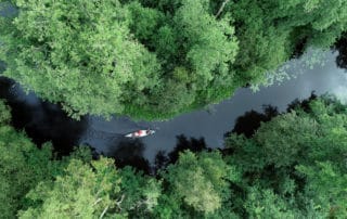
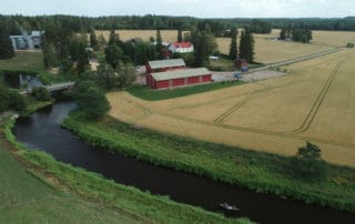
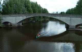
- The route starts at the Koskikara rest area near the Koskikartano Café and Restaurant by National Road 12. There is plenty of parking space, and a trail leads from the rest area to the shore of the River Teuronjoki where you can find a dock for swimming and paddling purposes. The curvy river flows through a grove landscape and soon passes under the bridge on Road 12. Gradually, the noise of traffic fades away and is replaced by the cascading sound of the rapids near the historical Hankala flax breaking facility. The old flax processing plant, that used to be owned by the pioneering industrial company Tampella, has been renovated and is open to guests on request. Canoes must be carried past the dam and a short way downstream on the left riverbank. The route continues in a magnificent forest landscape, and soon after the Hankalankoski Rapids, you arrive at the Hyväneulankoski Rapids, whose descent line is in the middle (Class 1–2) if the water level is high enough. Slowly, the forest thins out, and the riverbanks turn steep. Every once in a while, paddlers get a glimpse of Häme’s field landscape. You reach the village of Myllykylä after paddling for approximately 16 km. The upper part of the Myllykylä Rapids is not paddleable because of the built structures in the river. However, the structures can be passed on the left side of the concrete slope. Under the rapids, there is a lean-to that can be freely used by campers. - The next milestone is the Lake Mommilanjärvi lean-to and swimming beach in the village of Haminankylä, approximately 16 km from Myllykylä. From Lake Mommilanjärvi, the route continues via the River Haminanjoki to Lake Ansionjärvi. Next, paddlers pass the Oitti population centre on the curving River Puujoki which flows all the way to Lake Kernaalanjärvi. Before arriving at the lake, you pass the Leppäkoski population centre where you can still see the old smokestack reach for the sky – a reminder of the area’s history as a central site for the brick industry. The distance from Lake Mommilanjärvi to Lake Kernaalanjärvi is nearly 40 km. It is passed in a fertile rural scenery typical to southern Finland. - Lake Kernaalanjärvi collects its waters from five headwater lakes in the catchment area of Lake Vanajavesi: lakes Pääjärvi, Loppijärvi, Kaartjärvi, Renkajärvi and Takajärvi. From here, the waters flow north as the River Hiidenjoki, and the paddling route continues in abundant volumes of water. The route passes through the Turenki population centre, and after approximately 15 km, paddlers arrive at Vanajavesi’s Miemalanselkä Open. From here, Vanajavesi continues as a narrow route towards the city centre of Hämeenlinna, and boat traffic starts to increase. The distance between Lake Kernaalanjärvi and Hämeenlinna is 23 km. - Lake Kernaalanjärvi collects its waters from five headwater lakes in the catchment area of Lake Vanajavesi: lakes Pääjärvi, Loppijärvi, Kaartjärvi, Renkajärvi and Takajärvi. From here, the waters flow north as the River Hiidenjoki, and the paddling route continues in abundant volumes of water. The route passes through the Turenki population centre, and after approximately 15 km, paddlers arrive at Vanajavesi’s Miemalanselkä Open. From here, Vanajavesi continues as a narrow route towards the city centre of Hämeenlinna, and boat traffic starts to increase. The distance between Lake Kernaalanjärvi and Hämeenlinna is 23 km. - Lake Vanajanselkä opens wide just a stone’s throw from Lepaa, and paddlers enter the magnificent lake scenery dotted with islands. The route travels northeast by the Vanajanniemi Cape to Petäys Resort beach which is the end point of the paddling trail. Here, you can take a relaxing bath in the sauna, eat and rest after the long journey. The distance between Lepaa and Petäys is approximately 8 km. - Good to know - The Vanajavesi paddling route is suitable for beginners and experienced paddlers alike, although the open waters are challenging in windy conditions. Experienced paddlers traverse the route in three days, but if you intend to enjoy the views, services and numerous historical sites to the full, you can spend an entire week on the route. As the route passes through numerous population centres, it is easy to choose a suitable stretch to paddle. The initial part of the route includes short stretches where canoes have to be carried (Hankala flax breaking facility, Myllykylä Dam on the River Teuronjoki and Vuolteenkoski Dam on the River Puujoki). Otherwise, the route is easy, and water volumes are abundant from Lake Mommilanjärvi onwards. In general, the route is paddleable throughout the season. The section between lakes Mommilanjärvi and Vanajanselkä can be paddled both ways. -Canoeing services: Teuronjoen Latu ry, Enicare Oy, Vanajaveden Vesikot ry, Aulanko Outdoors, Petäys Resort, Pinnalla Oy
Food services: Koskikartano, Suviranta, Turengin Wanha Asema, Hotelli-Ravintola Mesku, Satamaravintola Pumppuhuone, Virvelin Rantaravintola, Hämeenlinnan palvelut, Rantakasino, Original Sokos Hotel Vaakuna Hämeenlinna, Scandic Aulanko, Lepaan Kartano, Lepaan viinitila, Petäys Resort
Accommodation services: Hotelli-Ravintola Mesku, Hämeenlinnan palvelut, Original Sokos Hotel Vaakuna Hämeenlinna, Scandic Aulanko, Katajistonranta, Lepaan Kartano, Petäys Resort
Level of difficulty
The route can be paddled in 3–7 days, and its level is easy.
-Route start
The paddling route starts from the Koskikara rest area close to the Koskikartano Café and Restaurant on the left-hand side of National Road 12 when approaching from Tampere.
-START AND END POINTS:
Koskikara rest area (Koskikartano), Tampereentie 655, 16800 Hämeenkoski, 61.017304, 25.160827
Myllykylä (River Teuronjoki), Myllykyläntie 209, 16610 Kärkölä, 60.910594, 25.213211
Soidanlahti (Lake Mommilanjärvi), Haminankylä, 12130 Hausjärvi, 60.847634, 25.028649
Leppäkoski swimming beach (River Puujoki), on the right side of Haukankalliontie Road, 12380 Janakkala, 60.860557, 24.709062
Suviranta (River Hiidenjoki), Turengintie 31, 14200 Turenki, 60.920044, 24.620216
Hämeenlinna swimming hall beach (Lake Vanajavesi), Uimarintie 2, 13100 Hämeenlinna, 60.991332, 24.467366
Katajistonranta (Hattulanselkä Open), Katajistontie 1, 13220 Hämeenlinna, 61.030733, 24.442606
Mierolan Silta Cafe (Lake Vanajavesi), Ventolantie 2, 13720 Parola, 61.063530, 24.388953
Lepaa pier (Lepaanvirta), Laivalaiturintie, 14610 Hattula, 61.111406, 24.325361
Petäys Resort (Vanajanselkä Open), Petäyksentie 35, 14620 Tyrväntö, 61.159280, 24.322778
-ROUTE MARKINGS: The paddling route is easy to follow using the DigiTrail app.
-ROUTE SUITABILITY: The route is suitable for families and beginners, with the exception of the open waters.