DigiTrail Canoeing trails
River Toivanjoki canoeing trail, Janakkala
Route description
The River Toivanjoki paddling route is 8.7 kilometres long. The calmly flowing river can be paddled both ways. When paddling downstream, it is advisable to start at the Lepokallio swimming beach and boat landing site on Lake Kesijärvi. In addition to the parking area and toilet facilities, the swimming beach is equipped with a picnic table.
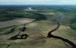
-When starting at the Lepokallio boat landing site, the right direction can be found easily by paddling towards the power lines under which the River Toivanjoki runs. You only have to paddle on the eastern shore of Lake Kesijärvi for approximately 15 minutes before reaching the outlet. On the way you can admire the old brick factory milieu. The mouth of the River Toivanjoki opens as a wide streambed, and the slowly flowing river remains similar throughout the route.
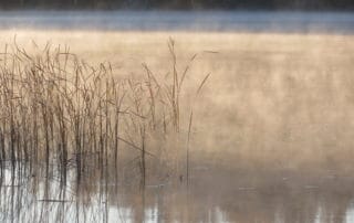
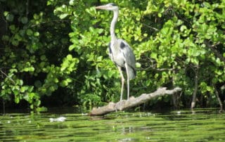
-The riverbanks with their tall reeds provide a paradise-like setting for birdwatchers. It is a good idea to bring a pair of binoculars as the diversity of water birds is guaranteed. At the beginning of the growing season in the spring, the visibility beyond the reeds is excellent, and you can spot cranes walking slowly in the flood meadows. The diversity of bird species is highest in the preserved Toivanjoki water bird wetland which is easy to identify by the tall birdwatching tower at the forest edge. In 2014, more open water areas were excavated as safe breeding and feeding grounds for birds in the paludificated wetlands. In addition to cranes, you can also spot great bitterns, common curlews and marsh harriers in the wetlands.
-There are only a few rest areas by the River Toivanjoki. An idyllic wooden bridge, by which canoes are easy to drag, has been marked approximately halfway through the paddling route. The wide bridge railing is comfortable to sit on while enjoying a meal, the summer weather and the charming river scenery.
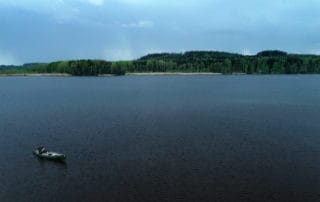
-After the water bird wetland, the edges of the forest start growing steeper and the imposing Takalankallio Cliff rises above the lake on the right-hand side. Soon after, the river joins the Kuosarinlahti Bay of Lake Alasjärvi. After a while of paddling, you reach the open water of Lake Alasjärvi and the amusement park Puuhamaa becomes easily visible on the opposite shore. In addition, you can distinguish the beautiful yellow Tervaniemi Manor as well as the adjacent end point of the paddling trail, the swimming beach maintained by the community organisation Suruton. There is a lean-to shelter in the vicinity of the beach. There you can rest for a while before carrying the canoe uphill to the swimming beach parking area.
-Good to know
The River Toivanjoki route can be paddled both ways, and it is easy to return to the starting point thanks to the river’s calm flow. The route can be paddled whenever the river is not frozen. The cottage and sauna by Lake Alasjärvi as well as SUP boards can be rented from the association Suruton ry. There are swimming beaches at both ends of the route. The River Toivanjoki has a diverse bird life and there are two birdwatching towers along the route, the Luulio Tower by Lake Alasjärvi and the Toivanjoki Tower by the water bird wetland.
-Level of difficulty
The route can be paddled in approximately 2 hours, and its level is easy.
-Route start
You can start the route from Lake Kesijärvi or Lake Alasjärvi. Lepokallio boat landing site on Lake Kesijärvi: turn from Road 54 towards Tervakoski. Drive 1 km along the Vähikkäläntie Road from the Launos crossing towards Tervakoski. Turn left and drive 2 km along Suviniementie Road. Turn right and drive 250 m (signless crossing). Suruton’s beach on Lake Alasjärvi: In the Tervakoski population centre, turn left from the Vähikkäläntie Road to Tervajoentie Road. Turn right to Tammirannan puistotie Road after crossing the river. Turn right to Alasjärventie Road. Suruton’s beach is located approximately 1.5 km from the Tervakoski population centre.
- -
START AND END POINTS:
Lepokallio boat landing site, Kesijärvi (Loppi), 60.753351, 24.533189
Suruton’s beach, Alasjärventie 9, 12400 Tervakoski (Janakkala) 60.802607, 24.616444
-ROUTE MARKINGS: The paddling route is easy to follow using the DigiTrail app.
-ROUTE SUITABILITY: The route is suitable for families and beginners.