Häme Castle

The decision to establish the Häme Castle is related to the Tavastian ‘crusade’ of Birger Jarl in 1239 or 1249, but the initial construction work of the castle was probably launched in the late 1200s. The objective of Birger Jarl’s crusade was to join Tavastia more closely to the new home country under the Swedish crown. It also led to the construction of a military base, though the incentive was also to receive tax revenue.
The oldest part of the castle is formed by the so-called fortified camp. It included a square-shaped greystone wall, with defensive towers in three corners. In addition to the surviving walls, there is a 12-metre-deep well in the so-called well room of the castle. However, there is no water in it. The interior of the old fortified camp was later modernised by means of vaulted brick rooms. These also included the main hall of the castle, which is the oldest surviving banqueting room from medieval Finland.
The next stage began in the 14th century. Two new matters had to be taken into consideration in the construction: appearance, and in terms of defence, the development of firearms. The construction periods in the late 14th century and 15th century are called brick periods. The use of brick for construction and for façades in particular allowed for increasingly refined spatial solutions and more ornamental details, which is clearly manifested in the walls of the castle courtyard.
The Swedish King Gustav Vasa changed and modernised many things in his kingdom in the early 16th century. The Catholic Church had to make way for Lutheranism, and the objective of modernising administration was to place the kingdom strictly under the King’s control. For Häme Castle, it meant that the residence of mighty nobles became strictly supervised by the royal accountant and was turned into a controlled military base. Two strong gun towers were added to the equipment of the castle, but in spite of all of this, Häme Castle began to decline slowly.
The fraternal disputes of the Vasa family during the Cudgel War of the late 16th century also affected Häme Castle, whose old south tower was destroyed in an explosion during military activities. The explosion resulted in thorough repairs, which led to the construction of the Lutheran Church in the Gate Tower.
Gustav II Adolf and his wife visited the castle in 1626. The King’s Hall and the Queen’s Chamber were named in honour of this visit. Another visitor was Governor-General Per Brahe, who visited the castle in 1639, at which time he also made the decision to establish the town of Hämeenlinna. By order of King Gustav III, the town of Hämeenlinna was moved to its current site during his visit in the 1770s.
After many efforts, restoration work on the main castle began in 1956 and it was completed in 1979. The same year, the museum at the Häme Castle was opened to the public. The square walls were finished in 1988.
The museum is open from Tuesday to Friday between 10 a.m. and 4 p.m., and on weekends and public holidays between 11 a.m. and 4 p.m. The museum is closed on Mondays. In the summer period between 1 June and 14 August, the museum is open to visitors every day between 10 a.m. and 5 p.m. In addition to the permanent collection, there are periodical exhibitions at the castle, and facilities may also be rented out for celebrations or meetings. In the region, the annual Häme Medieval Festival is organised each year in August. In addition, there are Easter markets and many other events.
Häme Castle as a prison
Prisoners had been kept at the castle since the Middle Ages, but eventually, in 1837, the entire main castle was turned into a prison as the castle was no longer needed for military and administrative purposes. The square wall structures of the castle were expanded, and new facilities were constructed for the prison. At its broadest, the prison area consisted of approximately 40 buildings. When the actual new prison building was completed in 1872, it was Finland’s first prison with cells, and it was intended to be used as a penitentiary institution for male prisoners. The Häme County Prison was initially located at the castle, but it was subsequently transferred to this actual prison building.
A separate cell prison for female prisoners and a correctional institution were located at the main castle between 1883 and 1972. The prisons in the area were administratively merged into the Hämeenlinna Central and Country Prison in the 1920s. The last prisoners were moved away from the castle in the 1950s when its restoration work for use as a museum began. After this, they were prisoners in the area, working in a penal colony to repair the castle. The women’s prison was closed in 1993. The buildings were taken over by the Finnish Heritage Agency for protection. Two years later, plans were made to establish a prison museum in the facilities. It was opened in 1997.
The castle prison was used for arrests and detentions in exceptional circumstances during the Russification period in the early 1900s and during the Civil War (1918) and the Lapua Movement (1929-1932). During the Winter War, the Continuation War, and after the war, war criminals and individuals hiding weapons were also taken there.
Ojoinen
Ojoinen was densely populated before the construction of the castle. The construction work of Häme Castle began in the late 13th century, and the work was carried out by local peasants, particularly men from Ojoinen. In addition to the construction work, they were obliged to provide grain and livestock products to the castle as taxes. At the time, all land belonged to the crown, and peasants had to pay taxes for the land they cultivated. If taxes were not paid for three years, the farm was repossessed by the crown in its current state.
The Ojoinen village was closest to the future Häme Castle, and its lands were turned into the castle’s first and largest farming manor, whose foremost purpose was to feed the castle. Gradually, in the 15th century, the initially free peasants became tenants who paid the farming manor taxes for their farm. The position of the those living on the castle farming manor lands became increasingly difficult in the 16th century, since they were only given two alternatives: give up your house or come to work as hirelings at the castle.
Peasants from the neighbouring parishes cultivated the land as part of their labour duty under the supervision of bailiffs. The work was divided between various parishes: the people of Janakkala were in charge of ploughing in the spring, the people of Renko planted the peas, the people of Lehijärvi cut the hay, etc. All ploughing activities and crops were carefully accounted for. In 1539, there were only six hired members of the staff at the Ojoinen manor: the livestock manor employee or director, the livestock manor employees wife or the mistress, the farmhand, the goose herder and two milkmaids. In addition to those receiving annual salaries, herders were hired in the summer. Instead of money, they received four pairs of shoes as well as felted woollen cloth and linen in exchange for their services.
The castle accounts also provide a detailed idea of the livestock and how it was used. The largest amount of livestock was 45 cows according to the 1576 accounts. If the accounts did not match, and there was misuse, the bailiffs were severely reprimanded. Horses were the most valuable animals in the livestock, and they were used for breeding, labour, travel and riding.
Later in the 17th century and the early 19th century, the Ojoinen manor was a benefit in kind for the Häme County governor. Pyövelinmäki, which is located north of the castle, was part of the Ojoinen manor, and its owner Governor Rehbinder began to turn the Pyövelinmäki hill into a park in the 1840s. Prisoners were used to plant broad-leaf trees, artificial rulings were built, and Parkki, the current City Park, was constructed. The shore has a renovated stone quay, and there are more than 5 kilometres of walking routes in the area.
The main building of the manor as well as the stone pig house and wooden stable building all date back to the 1870s. The land came to be managed by the prison administration department of the Ministry of Justice as the prison activities began in 1928. The two-storey prison building was constructed of brick in 1930, and the granary, also made of brick, was completed in 1931. The prison is used as an open prison.
When Finland was taken over from Sweden by the Russian Emperor in 1809, the Emperor stationed between 300 and 400 Russian soldiers at Häme Castle. The situation was difficult for a town of 1400 inhabitants, and at the demand of the habitants, permission to build Castle barracks in the middle of the 19th century was finally received. They were later used by the Finnish Defence Forces, and Museo Militaria or the artillery museum is operating in the facilities today. Some of the barracks have become part of the housing corporation.
After the Continuation War in the late 1940s, ‘war veterans’ homes’ were constructed in the Ojoinen district to relieve the housing shortage. These were wooden detached houses with one and a half storeys and a ridge roof. All living quarters were located around the single chimney in the middle of the house. Downstairs, there was a hall, two rooms and a kitchen, and upstairs, there was space for two rooms by the wall of the house. The house often also included a basement. In the Ojoinen district, the new streets were named after the place names in the parts of Karelia surrendered to Russia.
Pikku-Parola
 Pikku-Parola was at the junction of roads as early as the Middle Ages. In addition to the Ox Road of Häme, the Kyrönmaantie road, leading to Ostrobothnia and Satakunta, passed by the village. The Parola village was once part of the Vanaja parish. The inhabitants of Hämeenlinna suggested to King Gustav III in the 1770s that the parish be annexed to their town. However, the King refused, and the inhabitants requested five villages from Vanaja. They were not annexed to the town either. Instead, they were transformed into the Hämeenlinna country congregation.
For centuries, the centre of the Parola village was located at the site of the current Hämeenlinna industrial zone. Today, the village has been named Pikku-Parola to distinguish it from the Parola located at Hattula. In addition to original estates, there were crofter cottages and cottages owned by independent country dwellers along the old road. Crofters were tenants in large farmhouses or manors. They worked for third parties. Crofts included a small plot of land where swedes, turnips and later potatoes could be cultivated for their own consumption. Independent country dwellers were also tenants, but they did not engage in farm labour. Instead, they were usually artisans.
The Great Partition was carried out in Parola village in 1785, and a new partition took place in the middle of the 1890s. Eskola was divided between two houses: Maantie-Eskola was slightly further away, and in addition to Kylä-Eskola, the village centre consisted of Pietilä and Kiltti. Mäkelä was located on a hill east of the village. Two of the original houses of the village, Kiltti and Pietilä, remain.
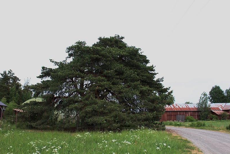
The Kiltti estate has been owned by the same family since the 16th century. It is mentioned in the 1539 urbarium, where Maunu Henrikinpoika is stated as the owner. In 1696, the first riding farms were established in Häme, and in Parola, they were Kiltti and Mäkelä. One hundred years later, the Kiltti estate was divided between brothers into the Iso-Kiltti and the Vähä-Kiltti estates. In 1880, the owner of the Iso-Kiltti estate had to sell his estate in an auction due to his debts, and it was purchased by Eerik Vähä-Kiltti, once again reuniting the Kiltti estate. Eerik Kiltti was married twice and had a total of 15 children, but only three of them survived by the time their father died at the age of 90 in 1932.
On the boundary of the Kiltti estate, there is a 400-year-old protected pine tree. In the 1990s, its circumference was 496 cm. Väinö Kiltti the elder protected the tree using a fence in the early 20th century. The history of the pine tree includes a visit made to Parolannummi by King Gustav III in June 1783, and a visit made by King Gustav IV Adolf to Hämeenlinna and Parola in summer 1802. It is said that their entourage dined under the pine tree, which is why the pine tree came to be called the King’s pine tree. The tradition continued though Finland was taken over from Sweden by the Russian Emperor. The Russian emperors Alexander I and Alexander II also enjoyed a meal under the same pine tree in 1819 and 1863, respectively. During the visits by Alexander II, there were great celebrations on the site. In addition to the Emperor’s entourage, local people also participated in the festivities. The pine tree has been called the Emperor’s pine tree ever since.
Pikku-Parola may be considered a typical example of how an agricultural village gradually becomes an urban district. When the village was annexed to the town in 1948, there was much-needed industrial land available for Hämeenlinna. The town planning was completed in the late 1960s, and the city bought land from the estates for its own purposes. The Kiltti estate was still farmed the 1970s, but the siblings who were the last owners of the estate did not marry or have children. According to the will of one of the siblings, the property was left as a heritage to the Väinö and Hilkka Kiltti Foundation, which supports research, for instance research into cardiovascular diseases and ocular diseases.
Pullerinmäki
Tiiriö, which formerly consisted of fields and marshes, has become a centre for commercial services, Viisari is a mainly residential area, and Rinkelinmäki is certainly best known in Finland for its ice stadium, which is a matter of importance. Finland has tradition of ice hockey. The ice stadium was completed at Rinkelinmäki in 1979, and is called Ritari-areena today. It hosted competitions such as the Ice Hockey Women’s World Championship, with the United States winning the gold medal, Canada the silver medal, and Finland the bronze medal.
The Hämeenlinna Prison was constructed in 1972 in the Pullerinmäki district. It was initially only intended for female prisoners, but as the number of female prisoners decreased, men also were housed there. The majority of Finland’s female prisoners are still housed in the Hämeenlinna Prison. The prison has both closed and open departments and a national family department where female remand prisoners may be housed with their child under two years of age. There are a total of 173 places for prisoners. The prison laundry is in charge of washing all of Finland’s prison laundry and repairing shoes. It also has a national central warehouse for convicts’ clothes. A new prison building is being constructed in the prison site. Modern technology is intended to be used for supervising the prisoners and for their studies.
Tiirinkoski
 The Tiirinkoski district mainly consists of fields and forests, farms and detached houses. The Myllyoja river, which empties into Vanajanselkä, flows through the district. It is presumed that the village was named after the rapids in the Myllyoja river. The rapids have been important sources of power for mills and sawmills for centuries. Their importance is reflected in many features such as place names, including Tiirinkoski.
Tiirinkoski was once an auxiliary estate for Kirstula manor. Tiirikoski was a dairy farm where grain and sugar beets were cultivated. Cultivation was abandoned in 2012. At this time, cultivation went in a new direction, and currently, broad beans are cultivated at the estate in addition to grain. In addition to agriculture, the entity operating under the name of Tiirinkosken Tehdas also includes a domestic animal farm where people can get to know sheep breeds originating in Åland and Gotland as well as Highland Cattle, cats, dogs, chicken, and in summer, rabbits as well.
A new kind of interest in food has also transformed the agriculture. One example of this is the Tiirinkoski Härkäpapu from Hämeenlinna, cultivated in the Tiirinkoski farm. An increasing number of Finns are interested in how healthy food is, and partly due to this, they are interested in buying food produced in their own country. The broad bean is one of the plants that is becoming increasingly popular. It was cultivated in Finland before peas and potatoes. The broad bean is a legume which contains carbohydrates that are absorbed slowly, plenty of fibre and protein and only 1% fat. The broad bean is used in sauces, soups, casseroles and salads.
In addition to agriculture and the domestic animal farm, Tiirinkosken Tehdas has a shop and a cafeteria operating in a former cow shed constructed in 1910. Various broad bean products, such as crushed and ground broad beans, can be purchased there.
Vuorentaka
The Rääpiälä area at Vuorentaa has a versatile history. Part of the old Vuorentaa village site was located there, and in experimental archaeological excavations, structures from the 19th century and possibly from the 18th century have been discovered there. More recent history is represented by the main building of Rääpiälä, which was one of the horse farms in the village, constructed in 1928. The cowshed and the granary, made of concrete brick, also date back to the same period.
After the war, one of Finland’s eight internment camps was established in Rääpiälä. In the truce agreement, Finland had committed to cutting its ties to Germany, and as a part of this, Finnish internment camps were established in autumn 1944 at the demand of the Allied Control Council. Originally, only German soldiers were intended to be isolated, but the British members of the Control Council also demanded that civilians be isolated.
Approximately 500 German and Hungarian citizens staying in Finland were sent to the camps. Subsequently, their Finnish spouses, mothers, and children were also taken there. There were 170 Finnish-born internees. The internees lost their property to the Soviet Union. The majority of them were released in March 1946, but the last ones were only liberated in summer 1947. The Rääpiälä camp was the smallest of the camps, and in spring 1945, there were 24 internees. Its facilities were confined, internees slept on paper mattresses, and their food consisted of dried potatoes and sauerkraut. The camp was closed down in August 1946.
The Rääpiälä buildings were owned by the City of Hämeenlinna, and the main building was turned into an orphanage in the 1940s, and an additional wing was added to it. The main building has also operated as a centre for autistic patients, and lately, as a private nursery. The fields surrounding the area are still being cultivated.
In the Vuorentaa village, currently a district of Hämeenlinna, there is also a cemetery with the Vuorentaa Chapel, completed in 1971. The building has a large and small cemetery chapel and a crematorium.
At Vuorentaa, the Ox Road of Häme intersects with Marssitie. Marssitie is a special transportation route. Deliveries which do not pass under bridges are directed there.
Hyrvälä
 The Hyrvälä and Kouvala areas were apparently inhabited as early as the Stone Age, either permanently or for hunting. According to an archaeological inventory made in 2008, there are Stone Age dwellings in the area, for instance at Härkälänmäki. The Hyrvälä village landscape has mainly remained unchanged since the early 1800s.
In the Middle Ages, there were at least three houses at the Hyrvälä village, since the names of three owners are recorded in the protocols for court sessions held in the 1470s. House owners took turns in serving as lay members of the court. Courts have many duties, and they were not assembled for legal proceedings alone. They also ensured the parish administration, and court sessions were an important place where peasants could also bring their own issues forward. Courts were assembled by the Sheriff elected from among the most notable peasants in the parish. The Sheriff was also in charge of general order.
The 1540 urbarium has records of six houses, and the same houses are also drawn on a map made 300 years later. All plots with houses in the centre of the village are beneath the current centres of farms. This means that the village site by the northwestern bank of the river is still inhabited. No signs of house ruins have been discovered in the surrounding fields. According to tradition, the site of the mill was located west of the village site.
It is known that the Hyrvälä village burned down in 1576, and the houses in the village were deserted for a long time. The houses being deserted did not mean they were uninhabited or that their lands were not cultivated. It meant that the inhabitants were unable to pay taxes. At the end of the century, King John III enfeoffed two of the houses to the Tattiani brothers, Russian Boyars, to thank them for defecting from Russia to serve Sweden. It was a common practice for rulers to reward noblemen in particular by enfeoffing farms or entire villages to them and allowing them to collect the taxes for themselves.
At the beginning of the following century, these houses became military houses even in Hyrvälä. They were the equivalent of salaries for the military personnel, and they could cultivate the land themselves or engage stewards.
The earliest parts of the Jussila military house dates back to the 18th century, and over time, the house has been extended several times. The Tupala farm has been cultivated by the same family since 1639, and it was redeemed as a family estate in the 1860s. In the traditional way, the earliest part of the main building was preserved even in Tupala, though the current façade dates back to the turn of the 19th and 20th century. Apparently, the earliest building in the household is a dairy room from the 18th century which was once used as a facility for the travelling school.
The Great Partition took place in the Hyrvälä-Nihattula partition area between 1807 and 1814, and it was supplemented by the so-called land consolidation in 1912. The narrow, alternating field trips attached to houses, used in the open-field system, were transformed into more extensive field areas for single farms, and the woods common to the villages were divided. The land consolidation definitively forced people to move their buildings from the centres of villages close to their own fields. These partition activities have a crucial impact on what old country villages look like today.
On both sides of the Hyrvälä village sites, there are small rapids in the Alajoki River. It is known that there were mills in the rapids. Mills were usually jointly used by villages, and large mills had millers, but in small village mills, flour was ground by the people themselves. The percentage of flour depended on one’s possessions or the number of mantals, but in some cases, one could have a share in the mill by bringing timber and other supplies for constructing and repairing the mill. The mills have left no traces behind in the landscape.
Kouvala
 The Kouvala village may be considered a good example of the creation of the country landscape in Tavastia. On the northern shores of the ancient Alajärvi Lake, Stone Age dwellings and their forest clearances have been discovered. Some time after 2,000 BC, temperate broad-leaf forests came to be replaced by fir trees in the landscape. It is likely that there were small burn-beaten areas in the riverside, and clearances from the end of the Stone Age onwards. The clearances were modest cultivation sites cleared of trees and bushes. The burn-beaten areas were much more productive areas where the felled trees had been burned, and their ash was an effective fertiliser for cultivating grain.
Later, at the end of the 14th century or in the early 15th century, the area was permanently settled. The selection of sites for houses and villages was affected by the suitability of the soil for cultivation and rapids sites. There are medieval records on two houses and records on three houses in the 1540s. This situation continued up to the end of the 18th century.
The people began to think there was over-exploitation of forests as early as the 17th century, and some were taken to court for gathering firewood in a forest belonging to another village. Forests were mainly commonly used by villages. Burn-beating continued in the 18th century, and firewood and construction wood was needed in large amounts. Gradually, attention was also paid to forestry. Forests were valued in a new way with the expansion of the sawmill and pulp industry.
In the old villages of the region, the current landscape is fairly similar to the early 1800s. New buildings have mainly been constructed outside the old agricultural landscape. In the Kouvala area, fields and meadows have been cleared for new sites. At the same time, old fields have been allowed to reforest, since they are not suitable for modern agricultural machines.
The most recent village in the Kouvala area is the Kivijoki village, which consists of a single farm house. The history of the house is a typical example of the story of Tavastian farm houses. It was first mentioned in an urbarium from 1570, and later in documents from the 17th century as a croft for the Lahiste manor. There is a document from 1713 indicating that the Russians destroyed the house during the Great Northern War, and it remained deserted, or was unable to pay its taxes. In the early 18th century, the Great Northern War caused great losses to Sweden. The war spread to Finland, and Finland was taken over by Russia. It resulted in the destruction of many houses in Tavastia. At the completion of the Great Partition in the mid-1800s, the Kivioja farm house had been divided into two buildings.
In the Katinala-Nummi-Kouvola and Kivijoki partition areas, the Great Partition was completed between 1763 and 1853, and it was supplemented by the land consolidation in 1894. The purpose of the Great Partition was to replace the narrow, alternating field strips attached to houses, used in the open-field system, with unified field areas for each farm, and at the same time, the woods common to the villages were divided between the farm houses. The land consolidation definitively forced people to move their buildings from the centres of villages close to their fields. The two Kivijoki buildings are located by the Ox Road. The landscape is almost exactly like the agricultural landscape in the mid-1800s, and the road lines remain unchanged as well.
Uotila or Inkala was originally part of the Katinala seat farm, and it was mentioned as early as the 1539 urbarium. The old location of the house is shown on the 1799 King’s map, and in the early 19th century, it was moved to its current place by the shore of the Alajärvi Lake. Today, the Inkala manor is a versatile site for country tourism and conference visits.
Parolannummi
Vähä-Luolaja, which was located in the Parolannummi area in Hattula, is one of Hattula’s oldest villages, first recorded in archives in 1329. Parolannummi has been designated an area of national value.
The Parolannummi military traditions date back to the time of King of Sweden Gustav Vasa when the pasture of Häme castle was located in the Nummenkylä area. The region’s infantry and light cavalry were assembled in the area as early as the Thirty Years War, which started in Europe in 1618. Sweden joined the war in 1630, and Finns became involved in military action as well. The Finnish cavalrymen came to be called ‘hakkapeliitat’ in Germany after their battle cry, ‘Hakkaa päälle!’ (‘Give them a good beating!’)
The army was once again assembled at Parolannummi for the Great Northern War (1700-1721). Sweden lost the war to its opponents, which included Russia, Saxony, Denmark and Polish-Lithuanian Commonwealth, and from 1715, Prussia and Hannover as well. Parolannummi became a permanent exercise field for the army in 1777.
Parolannummi was one of the most significant military areas in Finland and it was also visited by heads of the nation. The Swedish King Gustav III visited the camp three times in the 18th century and King Gustav IV Adolf once. Once Finland was taken over by Russia, Tsar Alexander I visited Parolannummi once and Alexander II twice.
The meeting between Emperor Alexander II and Senator J.W. Snellman at the 1863 summer camp was a special event. As a result of the meeting, the Tsar signed a decree on 1 August 1863 to make Finnish equal with the Swedish language. In honour of the event, a bronze lion by Swedish sculptor Andreas Fornander was erected at the site in 1868.
Camp activities continued at Parolannummi in the early days of Finnish independence. During the wars, the camp area was turned into a permanent site for accommodation and exercises. Features such as an air force squadron were placed there. At the final stage of the Continuation War, there were nearly one hundred buildings. In late 1944, the Armoured Battalion was stationed in the barracks, and the following year, they housed the central marine depot.
In addition to the Armoured Brigade established in 1942, the Kanta-Häme Regional Office operates at Parolannummi under the Western Finland Military District, and from 1993, Panssarivarikko or currently Millog Oy, a company specialising in the maintenance of the equipment and materials for the land forces and the navy have also operated there.
The development of Parola into a garrison was definitively launched in the late 1940s when wooden dwellings and crew buildings were built in the area. Two timber dwellings built for officers remain today. In 1951, the construction of new garrisons began according to plans made by the Ministry of Defence. The construction has continued steadily, and the latest building to be completed was the soldiers’ home 1 in the middle of the garrison area, designed by Architect Osmo Laine in 1988.
The soldiers’ home has its own bakery, which is still best known for its doughnuts. Each soldiers’ home association with a bakery has a proprietary doughnut recipe that will not be disclosed. Parolannummi has two soldiers’ homes. The Hämeenlinna Soldiers’ home association established in 1918 is in charge of them.
The Parola Armour Museum, located North of the area, was opened in 1961. A new museum building was constructed next to the old so-called hidden cottage in 1987.
Vuohiniemi
 Vuohiniementie begins at the Myllykylä rapids, and the Vuohiniemi village road is midway along the Vuohiniementie road. The village has existed since the Middle Ages, and the oldest houses are called Paasia and Paavola. A so-called Luurila bird, an Iron Age artefact, has been discovered in the Luurila house grounds, but hardly any other prehistoric remnants have been found.
The village of Vuohiniemi was mentioned in records for the first time in 1506 when Olavi Antinpoika Paasia was a member of the board at a Kulsiala court session. The session was about the division between two houses, Paasia and Paavola, in the village. In 1508, the disagreements between the masters of these two houses were once again discussed at the Kulsiala court.
The first master of the Paasia estate, Olavi Kaupinpoika Paasia, is mentioned in documents from 1473. The name of Olavi Antinpoika Paasia, who is mentioned above, was recorded in 1506, and the third owner was named as innkeeper Kauppi Torinpoika between 1508 and 1510. Paasia was a tax-paying peasant estate until the 1580s, when it was enfeoffed to horse master Jaakko Antinpoika in exchange for his cavalry services. Paasia was a horse farm between 1617 and 1670, after which it was turned into a benefit in kind for the company blacksmith.
The Paavola estate was also owned by peasants from the 1550s to the 1650s, when it was given to horse master Matias Eerikinpoika Silverharnesk. The house was deserted for a long time in the 1670s, and the land was eventually cultivated by soldiers. In the 1690s, Paavola was annexed to the Paavola Nihattula Torkkola horse farm. The timber main building of Kylä-Paavola was constructed in the 1850s, and its cattle shed was made of red brick in 1938.
Queen Christina of Sweden rather generously distributed titles of nobility to soldiers distinguished by the army during the Thirty Years’ War. Horse master Matias Silverharnesk was given this name when receiving his title. He was from Nihattula in Hattula. In addition to the title, it was a common practice to give the persons concerned state land and a tax exemption for their estate. These estates were called rälssi estates.
Along the Vuohiniemi village road, there is an old two-story granary made of grey timber, and two outdoor buildings with a timber finish as a reminder of the former peasant village. Around the village road, there are some fields, a few dwellings that are used around the year and some summer dwellings, as is the case in many country villages that have now become silent.
The Vuohiniemi school was constructed in 1913 on the western shore of the Renkajärvi Lake on a site belonging to the Luurila house. It was used until 1973 when it was annexed to another catchment area.
In the early 1900s, Vuohiniemi was strongly influenced by the evangelical revivalist movement, and village volunteers constructed a timber prayer house for the movement in 1937. Artist Arthur Heickell, who used to spend his summers on the shores of Lake Renkajärvi, donated an altarpiece to the prayer house. The building is owned by the Lutheran Evangelical Association of Finland and is used for divine services or fairs during the most important church holidays.
Räyskälä
 The Räyskälä village was apparently settled in the 14th century. According to a 1539 silver tax list, there were three original estates at Räyskälä: Mattila, Pietilä and Kyttälä-Kourla. In 1549, Jussila too was entered into records.
Räyskälä has always been one of the smallest villages at Loppi. In 1870, there were 95 inhabitants. In 1950, there were 205 permanent inhabitants, and in 1999, only 60 inhabitants. In the early 1900s, forestry companies owned all estates in the village except for the estate of Pyhälammi. At a certain period, it was owned by Chamberlain Linder and the railway company Rautatieosakeyhtiö.
Chamberlain Hjalmar Linder was one of the wealthiest people in Finland. He owned several manor houses, such as the Kytäjä manor. He established sawmills and a pulp factory at Lohja, purchased the Högfors factories at Karkkila, was married to the sister of the former Finnish President Marshal Mannerheim, Sophie, for a few years in the late 1800s, and around 1917, he had 5,000 employees and 64,000 hectares of land. It is unlikely that he ever visited Räyskälä, as it was only part of his possessions.
At Räyskälä, there is the Poronpolku reindeer path, dating back to 1965, when agrologist Jaakko Estola acquired ten reindeer from Salla for experimental feeding. The reindeer farm was located on the land of the Teväntö village by the Poronpolku path, allowing people to get to know the animals while on the route. The reindeer left Loppi in 1974, but the path remained open to hikers.
Räyskälä sports aviation centre
In 1940, during the interim peace, the Air Force constructed an airport at the Räyskälä moor as a spare landing site for the Air Force, but it was not needed during the war. It became covered with forest while in disuse. The Hämeenlinna sports aviation club had to find a hobby site to replace the Parola aviation site, and it eventually began to clear the Räyskälä airport and expand it. The project also involved local inhabitants and other sports aviation clubs.
The official first flight was made on 15 May 1963. The first gliding competition was held during the Midsummer week in the same year. The competition was then called the First Räyskälä Competition, but today, the competition is known as Jannen Kisat. Several international-level competitions have also been organised at Räyskälä.
Later, several sports aviation clubs and many aviators found their way to Räyskälä. The Räyskälä sports aviation centre has become the most popular amateur aviation site in Finland and in the Nordic countries. Several different types of aviation are represented there. The most popular types are gliding and parachute jumping. In addition to these, there are ultra and motor aviators in the airport, model plane amateurs as well as hand gliders and paragliders. The sports aviation centre is also an important training site.
Today, the airport is used as a forest fire protection centre for the county, a rescue flight centre, a centre for gliding and motor aviation as well as a training site for parachute jumping.
Salonkylä
 The Salonkylä area is one of the oldest permanently settled areas at Loppi, and it is also the largest village in the municipality. An Iron Age cremation burial site discovered in the area of the Salo manor is an indication of the age of the original settlement. Cremation burial is an Iron Age burial custom from Finland and Estonia. It became particularly common in the seventh and eighth centuries. The cremated remains of the dead and their objects were scattered between rocks, mixed with ashes from other burials. Rocks may also have been piled on top of different burials.
In the 1650s, Queen Christina gave the Salo manor as a gift to the mayor of Helsinki, Lårens Håkansson. The farm was subsequently turned into a seat farm, and in the 1860s, the Salmio and Leppäniemi manors were separated from it. The Salo manor has also been used as a fishing manor, since in addition to agriculture, fishing was of great importance as well.
According to a story, a kind fairy, a half-a-metre-tall older man living in the Blue drawing room, lives in the main building of the manor. No one has seen him for a long time. According to the story, there are people with more information on this, but they are bound by a strict oath made at the cross. The oath was used to close the mouths of servants, and they were prevented from spreading information on the affairs of the manor.
The owner of the Salo manor, Officer Cadet A. F. Sohlman, began to manufacture iron bars from ore extracted from a lake in 1849. The following year, ironworks were completed at the Rautakoski rapids. Ore extracted from the lake was turned into melted iron in a hot oven, a blast furnace, in order to cast it into moulds and use it to forge many types of objects. Iron was used to make axes, pots, nails, hoes, manure forks, hammers and tethers for cows. In 1851, the factory was expanded by adding an oil pressing plant and a turpentine and tar factories. The factory was closed down in the early 20th century. The old iron industry has left its mark on the Rautakoski environment. There are remains of charcoal kilns and tar burning pits.
The Marskin Maja Lodge is one of Salonkylä’s special attractions. Mannerheim was the commander-in-chief of the Finnish Army during World War II, and after the war he was elected President of Finland. In 1942, he received a hunting lodge, a fishing lodge and a sauna made of round timber for his 75th birthday from the Rukajärvi front veterans. In 1944, the cottage buildings located on the shore of Lake Lieksanjärvi in Karelia were demolished and rebuilt on the shores of Lake Punelia at Loppi. Since 1959, the Marshal’s cottage has been a tourist attraction. In 1992, the Sisu Outpost Museum was opened in its proximity to honour the builders of the cottage.
The Salonkylä Facebook page describes the village as follows: “Salonkylä has it all: 178 inhabitants, plenty of summer visitors, the Marskin Maja Lodge, the Rautakoski ironworks, Riihisalo, Poronpolku, Häme cultural landscape, Stone Age and Bronze Age, the Linder channel, enduro, the manor shop, domestic animal farms…”
Tervalammi
The Tervalammi house at Loppi is a settlement for the Sokala house at the Vojakkala village. The Tervalammi house has been one of the most popular rest stops on the Ox Road of Häme. The building may have housed a guest house.
The founder of the Forssa company, Axel Wilhelm Wahren, purchased the Tervalammi house as a forestry farm and for cattle breeding. He had a cowshed built in the courtyard. Although the most significant activities of Wahren consisted of the establishment of the Forssa company in 1847 and the creation of an entire textile factory community, he was also interested in agriculture and forestry. Forest and field areas from various parts of southwestern Häme, and also by the Ox Road, were acquired for the company.
During the time of the Forssa company, the Tervalammi foreman was Aukusti Silen. During the Civil War, he and his wife lived at the Tervalammi house. At the last stages of the war, thousands of Reds and their families escaped along the Ox Road of Häme from the direction of Forssa towards Lahti, attempting to reach Russia. At night, the troops found accommodation in the houses by the road.
On 26 April 1918, a group of Reds under the leadership of a man called Gypsy Svante found accommodation at the Tervalammi house. A White detachment under Captain Lyytinen discovered their whereabouts and formed a chain around the house in the darkness. In the small hours, a one-hour gunfire began. During this time, the Silen couple was hiding in the basement of the house. During the gunfire, the Reds began to escape by crossing marshes in the direction of Lake Pääjärvi. Both Reds and Whites fell in the gunfire: approximately 30 dead people remained in the courtyard and around the house. Seven of the fallen Reds remain at the site. They were buried in the Hautanummi hill, 400 metres west of the house. At the order of the company, Aukusti Silen was involved at burying the Reds.
In 1947, a statue was erected on the site by the Vojakkala Friendly Society. It contains the date 1918. The horses killed during the gunfire were buried in four different graves, most of them behind the cowshed of the Tervalammi house. There are still visible dents on the grave sites and bullet holes on the wall of the house and the cowshed stone base.
In 1924, the house was purchased by Lyyli and Jalo Mäkelä. Their family also included Olavi and Kerttu and their little brother Eino. He later purchased the house from his siblings and started a family with Aili Silen in 1957. Eino drove a taxi until the age of 65, and in addition to agricultural work, he played the accordion. As a smallholder’s wife, Aili Mäkelä’s hobbies included oil painting. After Aili’s death, the agricultural activities came to an end. New times brought the Tervalammi theatre tractor (1999-2014) to the Ox Road.
Bus traffic began at Tervalammi in the late 1920s. The first vehicles were so-called mixed wagons, with a pallet behind the cabin. The pallet was equipped with seats. The schedules were flexible. In summer, Tervalammi children picked strawberries and sold them to bus travellers when the drivers were friendly enough to stop long enough for them to trade
The telephone arrived at Tervalammi in 1926, and in its honour – and to collect funds – the telephone company organised an evening party or the Tervalammi fair. Plenty of people arrived, even strangers, since the Imatra power lines were being drawn nearby. There was lot of liquor, and during the evening, there was a fight between construction workers and local men. The Räyskälä police were unable to calm the men down, and so the power line building contractor was invited over. He managed to quiet the men down by letting them know that those involved in the fight would be fired the following day. And that is exactly what happened.
Vojakkala
Vojakkala is one of the oldest villages at Loppi. It was settled by the early 13th century. The original estates of the village are located close to each other in the centre of the village. In the South, the village and the village fields are delimited by Lake Kaartjärvi and elsewhere by a forest area.
The Kallela main building represents a less common two-storey type. In the late 1800s, Kallela was a guest house. The Kallela granary is the oldest granary in the village, dating back to 1748. The long Lukana and Siukola main buildings are well-preserved 19th century buildings. As for the timber buildings at the Seppälä croft, they reflect the 19th century crofter period. Vojakkala is one of the cultural environments of national importance.
At Vojakkala, one of the Ox Road guest houses was located in the Kallela house. Guest houses were required for accommodating travellers, to allow them to rest and dine, and to change horses and transport prisoners. Guest houses were entitled to produce and sell spirits within a 20 km radius. House owners were obliged to provide horses and horsemen for transportation, to which Crown officials were entitled when travelling for business purposes.
Along the road, merchants transported goods such as weapons, jewellery, textiles, salted herring, spices and salt inland. They purchased tar, grain, cows, linen, knitwear, butter and fur for exports and for the needs of the crown. Markets were held close to churches. The old church of Loppi has been one of the churches impacted by the Ox Road.
Features such as the establishment of the village committee at Loppi in March 1980 among the first local village committees provides a good description of modern Vojakkala. Vojakkala was elected the most active village of Kanta-Häme in 1996. On the other hand, closing down the Vojakkala school in 2010 was a blow to the village and to its many activities. Along with the school, daycare provided for groups of children also came to an end, and the villagers lost their winter hobby and assembly facilities.
Fortunately, Vojakkala has a village association and sports club, Vojakkalan Valpas ry, which has been active since 1948. Together, they have kept the village alive and organised voluntary work over the decades: they have provided premises for the post office, detached houses for families with children and village history for everyone.
Organising dancing events at the Vojakkala bandstand in the summer season is one of their more widely known activities. Dancing with live music is no longer available in all villages or parishes. At the Vojakkala bandstand, it is also possible to participate in dancing exercises without a partner. Dancing music and exercise lovers have shown an interest in them. In addition, a publicly available exercise device has been installed next to the bandstand.
Kuittila
 In addition to Muurila, the oldest settlement areas of Renko have been found in the Kuittila village by the Ox Road of Häme. It may have been settled by the late Iron Age. A total of eleven medieval village sites have been discovered at Renko. One of them is located at Kuittila. All of these sites still contain buildings, or at least a few.
The houses at the village centre, Eskola, Latvala and Ali-Paavola are in a tight row, and the Ox Road is next to them like a typical village road. The houses were built close to one another before the Great Partition, and they were surrounded by fields under the open-field system. Each field area was divided into narrow strips so that by turns, each house in the village had a strip of its own. This requires the villages to cooperate for cultivation, and it was not always easy to assemble everyone in the field at the same time.
Kuittila also had a guest house and the related transportation stables. For travellers going from Turku to Hämeenlinna, it was the last guest house by the Ox Road before arriving in town. Organising transportation was a burden to the peasants, since Crown officials had to be transported, but they did not have to pay for transportation. The matter was corrected in the middle of the 17th century. Transportation became liable to charge, but the Crown also ordered the peasants to pay a new tax, the transportation tax.
In the Renkajoki river between Yläjärvi and Alajärvi Lakes, there are the Kuittilankoski rapids with a cooperative mill and sawmill jointly used by the houses. The cooperative consisted of the original estates of the village, but in some cases, one could have a share in the mill by bringing timber and other supplies for constructing and repairing the mill. Large mills might have millers, but house owners often ground the flour and sawed timber themselves. Today, there is a hut at the Kuittilankoski rapids which can be rented from the Kuittila cooperative.
Waterways were important in other respects as well. Once the lakes were frozen, the Ox Road travellers took shortcuts across the lakes. Rivers and lakes were of course important for fishing, but floating channels were important in order to transport logs from the woods. In Renkajoki river, logs were always floated to sawmills and factories when spring arrived. It required many log floaters, since the river is winding and narrow and passes through a long leg of forest. Many log floaters came to float logs each spring, and they were mainly known by their nicknames: the Härmä guy, the Liminka mower, the Tampere Number One and the Tampere Number Two, the Hauho base and Chaplin, who was a swarthy fellow. The log floaters would buy cheap American fat from the shop and rye bread and some milk from the houses and sit in the courtyards and eat.
It is said that before the wars, the people of Kuittila enjoyed doing sports the Ox road. There was still little traffic, which allowed them to do shot-putting and throw the hammer on the road. Sports equipment was stored between the Ali-Paavola and Yli-Paavola barn.
By the Ox Road, at Eskolankulma in the Kuittila Village, the Nieminen brothers lived with their widowed mother Miina. Their sad fate touchingly illustrates the cruelty of war. All four brothers, Niilo, Arvi, Olavi and Viljo Nieminen died in the Winter War and the Continuation War. Their mother Miina’s ordeal did not even end there. Instead, their house was destroyed in a fire a few years after the wars. A memorial stone was erected for the brothers at Eskolankulma by the Ox Road. There are happier memories of the Nieminen brothers as well. Before the wars, the agricultural society organised festivities. Once, the programme included an axe shaft carving competition. One of the brothers finished his shaft first and shouted: “All done, Niilo Nieminen!” This became a catchphrase for the village.
Lietsa
The Lietsa village is a cultural environment of national value, and the section of the Ox Road of Häme, which has been elected a museum route, passes through the village. Among the houses in the village, dating back to various periods, the oldest ones from the 18th and 19th century are built on a hill surrounded by small patches of fields. There are white birches by the village road, a large maple tree and a few old granaries.
In the village area, there is the Palsankallio boundary stone which was once an indication of the boundary between seven parishes, and it was mentioned already in the 1539 urbarium. Loppi, Tammela, Urjala, Sääksmäki, Kalvola, Hattula, Vanaja and the Renko Chapel under Vanaja radiated from the stone. The circle has been cut on top of the erratic boulder, a hole has been made at the centre, and seven boundary lines depart from the centre. The sign ‘81’ has been made on the southwestern side of the circle. The signs are not clearly distinguishable on the surface of the moss-covered rock. The building is surrounded by four piles of rocks indicating the direction of the boundaries.
According to the tourist map guide, the boundary stone was specifically related to the Ox Road of Häme: the parishes bordering on the road were in charge of the road maintenance, and it was simplest to agree on the rights to use the road at the joint boundary site. The Lynx Trail passes by the boundary stone, and on the other side of the Ox Road, there is a small parking area, and another tourist map guide indicating the sites in the area is located on the edge of the parking area. It has been assumed that the origin of the name Palsa is in the Russian word polosá, swathe (of land), strip, bed strip, or groove, but in Häme, the word also meant a part of the circumference of a cart wheel or a spinning wheel.
From the museum road, Jauhopolku or Rauniotie, which is actually part of the old Ox Road, departs in a southern direction. It can no longer be driven by car, but it can be otherwise used to return to the museum road. There is a small parking area and tourist map guides on both ends of the road. It is assumed that the detour was formed due to the hilly and rocky terrain. The Ox Road was challenging in many places, particularly for the very first automobiles, and it was said that on the hilly and rocky road, the rear lights were seen in front.
Muurila – kirkonkylä
 Muurila is the most important village in Renko, and it has been one of the most important villages by the Ox Road of Häme. In the middle of the Muurila village, by the Renkajoki river, there is Renko’s medieval Church of St. James the Great. As the church named after the Apostle St. James the Great, the church was one of the pilgrimage sites by the Ox Road of Häme, and the St. James Festival organised there attracted pilgrims from as far as Central Europe. It was a significant site, which is indicated by the fact that a German pilgrim arrived at the church in 1505.
Like the other grey stone churches in Häme, the church was constructed in the late 15th century. Among Finland’s medieval churches, it has a special feature, a rare octagonal base. The church has objects from the 18th and 19th centuries, such as altar textiles and candlesticks. The chandeliers date back to the 19th century and the early 20th century. The bell in the church tower is from 1800, and the more recent bell is from 1981. The earliest bell which is likely to date back to 1511, is located at the Ox Road Museum.
The cultural environment by the Renkajoki river is part of the provincially significant cultural landscape which begins at the most prominent village as a vast agricultural landscape following the Renkajoki river and the old highway. In addition to the river, the landscape is characterised by small lakes with houses constructed on the shoreline.
The map made in 1748 by land surveyor Westermarck indicated two Pietilä estates, the Mattila, Paavola, Laurila, Uotila (Otila) and Anttila estates in the village. Due to the Great Partition, land surveyors for the Swedish Crown were extensively operating in Finland. By order of the Crown, the houses had to give up the open-field system where narrow strips of field were next to each other, so that strips cultivated by the various houses in the village were included in the same field area. The Great Partition resulted in a division where village house owners were given larger field areas and forest areas in the woods which had previously been in common use.
The buildings were originally a compact group at the southeastern end of the Kirkkojärvi Lake and formed a compact village as village roads passed through the plots of land. Up to the late 18th century, courtyards were closed and surrounded by residential buildings and outbuildings on all four sides.
The Museum of the Old Ox Road maintained by Renko-Seura ry and owned by the Renko Peasant Foundation is located next to the Church of St. James the Great. The museum building is the former granary of the Renko mantal district, used for lending grain to satisfy the needs of the population. It was built in the mid-19th century. The Museum of the Old Ox Road houses rustic items, objects related to the Ox Road of Häme as well as objects related to the history of the Church of St. James the Great.
Many granaries used for lending grain have subsequently been transformed into local museums, since they were located in the middle of the parishes in their most prominent villages, and often next to churches. Granaries used for lending grain were established as storehouses by means of mutual agreements by parishes. They were used for storing grain in case of crop failures. By a decision made in 1756 at the Swedish Parliament, a granary used for lending grain was ordered to be established for the entire kingdom, including Finland. The need for parish granaries increased particularly in the early 19th century due to poor crops.
The line of the Ox Road of Häme has changed a few times, particularly at Muurila. In addition to pilgrims, tax collectors, soldiers and officials used the Ox Road, but it was of course also used by peasants travelling to the market at Hämeenlinna or Turku to sell their products. There were all types of travellers, who brought the people of Renko fascinating news from far and away.
Nummenkylä
Muurila is the most important village in Renko, and it has been one of the most important villages by the Ox Road of Häme. In the middle of the Muurila village, by the Renkajoki river, there is Renko’s medieval Church of St. James the Great. As the church named after the Apostle St. James the Great, the church was one of the pilgrimage sites by the Ox Road of Häme, and the St. James Festival organised there attracted pilgrims from as far as Central Europe. It was a significant site, which is indicated by the fact that a German pilgrim arrived at the church in 1505.
Like the other grey stone churches in Häme, the church was constructed in the late 15th century. Among Finland’s medieval churches, it has a special feature, a rare octagonal base. The church has objects from the 18th and 19th centuries, such as altar textiles and candlesticks. The chandeliers date back to the 19th century and the early 20th century. The bell in the church tower is from 1800, and the more recent bell is from 1981. The earliest bell which is likely to date back to 1511, is located at the Ox Road Museum.
The cultural environment by the Renkajoki river is part of the provincially significant cultural landscape which begins at the most prominent village as a vast agricultural landscape following the Renkajoki river and the old highway. In addition to the river, the landscape is characterised by small lakes with houses constructed on the shoreline.
The map made in 1748 by land surveyor Westermarck indicated two Pietilä estates, the Mattila, Paavola, Laurila, Uotila (Otila) and Anttila estates in the village. Due to the Great Partition, land surveyors for the Swedish Crown were extensively operating in Finland. By order of the Crown, the houses had to give up the open-field system where narrow strips of field were next to each other, so that strips cultivated by the various houses in the village were included in the same field area. The Great Partition resulted in a division where village house owners were given larger field areas and forest areas in the woods which had previously been in common use.
The buildings were originally a compact group at the southeastern end of the Kirkkojärvi Lake and formed a compact village as village roads passed through the plots of land. Up to the late 18th century, courtyards were closed and surrounded by residential buildings and outbuildings on all four sides.
The Museum of the Old Ox Road maintained by Renko-Seura ry and owned by the Renko Peasant Foundation is located next to the Church of St. James the Great. The museum building is the former granary of the Renko mantal district, used for lending grain to satisfy the needs of the population. It was built in the mid-19th century. The Museum of the Old Ox Road houses rustic items, objects related to the Ox Road of Häme as well as objects related to the history of the Church of St. James the Great.
Many granaries used for lending grain have subsequently been transformed into local museums, since they were located in the middle of the parishes in their most prominent villages, and often next to churches. Granaries used for lending grain were established as storehouses by means of mutual agreements by parishes. They were used for storing grain in case of crop failures. By a decision made in 1756 at the Swedish Parliament, a granary used for lending grain was ordered to be established for the entire kingdom, including Finland. The need for parish granaries increased particularly in the early 19th century due to poor crops.
The line of the Ox Road of Häme has changed a few times, particularly at Muurila. In addition to pilgrims, tax collectors, soldiers and officials used the Ox Road, but it was of course also used by peasants travelling to the market at Hämeenlinna or Turku to sell their products. There were all types of travellers, who brought the people of Renko fascinating news from far and away.
Kivilammen torppa
By the Ox Road Of Häme, there is a closed courtyard formed by the timber buildings of Kivilammi, which was once a croft for the Saari manor. The buildings have been exceptionally well preserved in their original condition, and they provide good insight into the life of crofters in the 19th century.
Kivilammi was first recorded in the Army documentation from 1523, and the croft was first mentioned in 1795, when the oldest part of the residential building was apparently completed. From the same period, there is a mention of a guest house on the right to produce spirits.
Prison guards and their prisoners also spent nights at the croft on their way from the Kakola Central Prison in Turku to Hämeenlinna. It is said that prisoners were locked up in a granary on the other side of the Ox Road. In one corner of the floor, there is a hole for relieving oneself. The door has visible marks left by heavy locks.
By the Ox Road, resting places were needed for people and the horses used for transporting them. It was worthwhile to stop at the Kivilammi spring in winter, since the water in the spring was warmer than water in a hole in the ice, and it was better suited for the horses.
The vegetation at the croft is a good example of the spread of plant species with travellers. The seeds of less common plants have reached the courtyard of the croft with people and animals. The same applies to many other resting places by the Ox Road. The special features of Kivilammi include the red plum and comfrey.
The Kivilammi croft is in private use.
Letku
 Letku is a village in the Tammela municipality in the province of Kanta-Häme. In terms of its natural environment, Letku is associated with the lake uplands of Tammela and its wilderness-type areas. The village landscape is a typical Häme landscape shaped by agriculture. The fields are by the Ox Road, and the woods further away.
Agriculture is the traditional livelihood in the village, though times have changed since almost all its inhabitants made a living cultivating land or engaging in forestry work. Today, people work at the centre of the municipality and in the towns nearby. There are approximately 30 companies at Letku, and approximately 20 farms. The majority of the farms specialise in cultivating grain, but there are also farms specialising in dairy, pork and sheep. The village has a village committee, the farmers’ association, a parental association, a fishing association and a hunt. There are 380 permanent inhabitants in the village, and almost 300 holiday residences. The village services include a shop, a post office in connection with the shop, and the school established in 1903.
The first shop in Letku was located in facilities constructed at the end of the Kunnas estate in the 1910s. The Lehtoranta shop started out selling slaughter animals and became a grocery shop in the 1930s. The third arrival was the cooperative shop Tammen kauppa, which was closed down in 1980 due to a lack of profit. Alongside these shops, the workers’ movement had its own cooperative shop, the Tammela Osuuskauppa. Its own building was first constructed for the shop in 1952.
In 1979, Tuula from Letku became the shop manager of the Tammela Osuuskauppa, which was renamed Hämeenkulma. However, six years later, a decision was made to close down the shop alongside other small shops, and the Letku properties were for sale. Tuula and her husband Pekka made an offer which was accepted. They renovated the facilities and acquired a storehouse. This is how they established the Letku Puoti shop.
The shop became a meeting place for the villagers and people residing in summer cottages, and various events were organised in its courtyard. Then Tuula and Pekka retired. After plenty of reflection, a cooperative was established in 2012. Subsequently, the cooperative was closed down, and today, the Letku Puoti is once again operated by a private shop owner. The shop also has a small cafeteria and petrol station.
A special event from spring 2008 is also included in the history of the shop. Then, the Letku Puoti shop was rented out for a few days for filming Panu Heikkilä’s short film The Cave. A large sign stating ‘Saarikoski shop’ was attached to the wall of the shop. People ignorant of film making wondered if the owner had changed when they visited the shop.
The public village building, the Letku Pirtti, is in frequent use. It organises festivities and various events as well as activities for children, adolescents, and arts and exercise lovers, and meetings are held there. The villagers have also received awards for their versatile and active work: in 2005 and 2012, Letku was elected the Village of the Year at Kanta-Häme. In summary, there is also the Ox Road Theatre at Letku. The place relates the history of the Ox Road and the village.
Liesjärvi
Signs of settlement discovered at Liesjärvi date back to the Stone Age, but the village was first mentioned in 1548. The crown repossessed woodlands from the area in the late 18th century in connection with the Great Partition, when the so-called surplus land was separated from the estates. The objective was to offer new land areas for new settlers to clear and cultivate. The Korteniemi estate was created in this manner in 1792.
The tilly soil is barren, and the area has remained sparsely populated for a long time. In the upland area of the region, old livelihoods and customs, such as burn-beating, burning tar and wood charcoal and living in chimneyless huts survived longer than in the surrounding areas.
Logs have been floated and iron ore has been extracted from the lake at Liesjärvi for the Högfors ironworks at Karkkila. A chopped firewood factory, a mill and an electricity plant once operated in the village. Many of the village services are still based on the opportunities provided by surrounding nature and forests. The former forest school is now called Eräkeskus Metsäkouluntie, and a special feature in the middle of the woods is the Keppana Kellari restaurant.
Liesjärvi National Park
The area of the Liesjärvi National Park is almost entirely covered by dense forests and small wooded marshes. Almost one half of the forests are fresh spruce forests. The area is characterised by lingonberry and bilberry heaths. The National Park also includes wilderness areas, ridges, beaches and beautiful lake scenery. The Park area has almost 50 kilometres of shoreline. The best-known natural attraction of the National Park is the low Kyynäränharju ridge with a sand beach. The ridge stands between two lakes.
The age of the forests varies greatly. A large section of the area was in forestry use until the establishment of the National Park. This is why there are plenty of young and middle-aged forests. However, some of the forests are more than one hundred years old. The primeval forests of the area which have been best preserved in their natural state, Ahonnokka and Isosaari, have been protected from all land and forest use since the 1920s. Valuable natural sites also include small raised bogs with endangered insects and osprey nests.
The bird species at the Liesjärvi National Park are typical of coniferous forests. The abundance of decaying trees is reflected in the large number of birds nesting in tree holes. In addition to the black woodpecker and the great spotted woodpecker, the three-toed woodpecker, the grey-headed woodpecker and the lesser spotted woodpecker nest in the Park. The chaffinch, willow warbler, spotted flycatcher, robin and redwing are the most common birds in the National Park. There are as many as six hawk species in the area. The black-throated diver is the king of the open lakes, and the red-necked grebe and the whooper swan nest in the sheltered bay areas.
Flying squirrels too reside in the large holed aspens on the lake shores of the National Park. Few people can see timid animals, but they can always see if yellow droppings can be found at the root of the aspens and whether the leaves have tooth marks on them.
Korteniemi Heritage Farm
The oldest data on the use of the woods in the National Parks date back to the end of the 18th century, when burn-beating and tar burning were still important sources of revenue in the area. However, burn-beating and tar burning and the resulting fires were devastating for the forests, and economic experts of the time were terrified at the state of the forests at Tammela and in southern Finland in general. Burn-beating led to the actual cultivation of grain in Finland. Trees were felled and burned, and the nutrients from the trees were derived from the ashes and used on the soil. No fertiliser was required for cultivating grain.
Tar burning was also a significant way of using trees. A tar burning pit was required for this. Its bottom was sealed up using peat and clay. Then the trees used for tar burning were layered in a circle, and a hole was left in the middle. The pit was covered using poorer quality wood, moss and earth. The fire was made in the pit, the tar derived from the wood flowed into the hole, and from the hole, through a pipe into a barrel. A large tar pit would burn for a whole week. Tar was a significant export product in the 17th and 18th centuries, when ship building increased in Europe.
The liberation of the saw industry in the early 19th century raised the price of wood, and the wasteful use of wood was restricted by legal means. The Finnish Forest and Park Service was established to manage state forests. Despite this, burn-beating and tar burning survived in the Liesjärvi area a long time after the restrictions came into force. Since the area was repossessed by the state in 1878, the Korteniemi crofter became a forest warden for the Finnish Forest and Park Service to monitor the use of forests.
In fact, Korteniemi has been settled since the Stone Age. The courtyard of the former forest warden’s estate at Korteniemi, along with its buildings, gardens and cultivation plots, has remained almost unchanged for more than one hundred years. In summer, people live on the estate as in the 1910s. The courtyard is full of sheep, chickens and roosters, and there are horses and cows in the pasture.
Porras
 The Porras village was established near the Ox Road of Häme in the early Middle Ages, and it became a centre for the area. Between 1563 and 1578, the administrative parish of Loimo or Porras included the current towns of Tammela, Forssa, Jokioinen, Humppila, Ypäjä and Somero and some of the Nummi-Pusula villages. According to tradition, the first church of Tammela was located in the village. Its exact site is not known, but the area next to the tanner’s workshop at Porras gives a hint about its location: the area is called Kappelinpelto, the Chapel field.
The traditional line of the Ox Road of Häme has been best preserved in this section leading from Somero to the Porras village. The name of the village is derived from the Ox Road bridge across the Turpoonjoki river, or porras, which means a causeway or a boardwalk. The old original buildings of the village were initially located near the bridge. Porras had a Sheriff’s house and a guest house as early as the 16th century. The last guest house operated at Talonen until 1936. The Porras village burned down in May 1822. Only two granaries remained by the ridge. One of them is still there.
According to the story, ‘the weather was warm, dry and windy. The cattle were in the pasture, and the spring seeding had been done. Most of the villagers were doing outdoor work, some further away and some closer to the village. At midday, the small number of villagers staying at home noticed that there was a fire on the roof of the residential building of the Luukkola house. The fire spread from rooftop to rooftop and from one building to another until the entire Porras village was engulfed in flames.’ They say that a cottage close to the remaining granaries was also left undamaged by the fire. The village on the hills east of the river was spared. By the village road, there are several houses and buildings that were constructed immediately after the fire.
In terms of cultural history, the most prominent of them is the closed Syrjälä courtyard complex, which is one of the best preserved building complexes in Häme. Its timber main building and outbuildings form a square closed courtyard accessible through two gates. Another traditional entity is formed by the Talonen building complex at the crossroads between the Ox Road and the Pusulantie road. Historically significant sites also include the trenches on the sides of the ridge constructed by Russians during World War I. However, they were never needed.
The tanner’s workshop at Porras is the only Finnish Museum exhibiting the leather industry of the late 19th century and the early 20th century which is located in its original site. The tanner’s workshop at Porras is a 500-square-metre industrial building, which was considered medium-sized in earlier times. In addition to the building, objects and materials related to old-time leather industry have been preserved at the workshop. Machines and devices used for leather manufacturing as well as shoemaker and saddlers’ tools are located in their original places. At the museum, visitors can get to know the entire process from the processing of raw hides to the manufacture and sale of finished leather products. There is also a restaurant and a cafeteria as well as meeting, banquet and accommodation facilities at the tanner’s workshop.
Porras has traditionally attracted artists. One of the best-known paintings depicting the village is At the Gate (1889) by one of the most prominent Finnish artists, Albert Edelfelt. Artists from Porras include Urho Salomaa (1902–1965), who worked in the village as a teacher, Pentti Hammarberg (1930-1991), a pupil of Salomaa and a native of Porras, and textile artist Pirkko Hammarberg (1932-2018). The Porras village centre also boasts the studio and the home of artist Eero Leppänen.
Saaren kartano
The Saari manor is located on an island between Lake Pyhäjärvi and Lake Kuivajärvi. The road leading to the Ox Road of Häme from the Tammela village (connecting road 2823) passes through the island. Across the Saarensalmi strait, there is an arched bridge made of steel concrete and reinforced using retaining arches above the deck, constructed in 1923.
The Saari manor was created in 1599 by combining many estates from the Saari village. Other estates were also annexed to the manor, and the manor was at its largest in 1918 before the Act on Crofters entered into force, consisting of approximately 3,500 hectares of land. At the time, there were 24 crofts belonging to the manor.
The two-storey main building was completed in 1820, and its columns represent typical manor architecture in the Swedish neoclassicist style. The surrounding park reaching the shore of Lake Kuivajärvi was built according to plans made in the 1920s and 1940s. The manor area consists of approximately 30 buildings, the oldest of which date back to the 18th century.
Magnus von Wright and Albert Edelfelt, who are among the best-known Finnish artists, have captured landscapes from the Saari manor in their paintings. Kaukola Ridge at Sunset (1889–1890), which was painted in the times of Edelfelt on a ridge near the manor, is particularly well known. The landscape in the painting is clearly visible from the viewing tower on the ridge. The viewing tower also has a memorial stone for Albert Edelfelt.
Saari Folk Park
The Saari Folk Park was established by the Home District and Museum Association for Southwestern Häme in 1932 on land rented from the Saari manor as a public site for recreational and leisure activities. The Folk Park is located on the Tammela uplands on the Kaukolanharju ridge range, which is a fascinating area in terms of landscape and geology.
The Lounais-Häme Pirtti, a home district building decorated with rustic objects, is located in the park. It is mainly used as a banquet restaurant. The building was constructed by volunteers between 1946 and 1948. In 1933, an open-air theatre was constructed on a slope inclined towards Lake Suujärvi.
The total surface area of the Folk Park is 48 hectares, and it is owned by the Tammela municipality and the City of Forssa. The Saari Folk Park has the Suujärvi clear water swimming pool and the Kuivajärvi sand beaches as well as two nature trails of approximately 3 kilometres complete with signs. By the Raanpää ridge trail, there is a laavu lean-to on the shore of Lake Kuivajärvi, and a campfire site. There is a 600-metre nature trail for visitors with reduced mobility.
There is also a village museum created by teacher Sulo Tanninen at the Saari Folk Park. The museum artefacts have been gathered from Liesjärvi village, and they mainly consist of 19th century objects related to agriculture, forestry, animal husbandry and the household.
Torro
According to the 1571 silver tax list, Torro village had five original estates: Kuru, Mäntylä, Pomppu, Marttila and Mänki. The estates were approximately the same size, and each estate had a horse, but there were three oxen at Marttila, two at Mäntylä, one at Kuru and none at all at Pomppu. Horses were given hay, and the straw was for the oxen. The rest of the castle had to settle for bundles of leaves from deciduous trees, particularly from birch trees, tied up and dried outside to be used as winter fodder. The Nikula estate was separated from Pomppu in the 1620s.
For the houses, the Great Partition from the 18th century onwards was a significant period. However, in many parts of the country it progressed very slowly. The Swedish crown issued an order that the narrow strips of field located next to each other and cultivated by people from each house had to be combined, and that each house should be given a uniform plot of field according to its mantal. In the same way, the commonly used forests in the villages were to be shared between the houses.
At Torro, the houses were constructed as a compact group by the village road, and the fields and the meadows were outside of the village, as was the custom at the time. It is stated in the protocol for the Great Partition that Torro had plenty of arable land which had been cleared recently. If the idea of Colonel Hastfehr, who had returned from Gustav III’s war, to dry the Torronsuo marshes and to turn them into arable land, had been realised, it would have been a truly great endeavour. Ditches were being dug, but the project proved hopeless due to the depth of the marshes.
In the early 19th century, a prayer house or a village church or chapel, as the people of Torro call it, and a graveyard, were constructed at Torro. They were all inaugurated in May 1801. Some time later, a bell-tower was constructed for the village church, and it was modernised in full in 1892. The current Torro graveyard was inaugurated in 1891, and in connection with the graveyard, a new chapel was constructed mainly by volunteers. It was completed in 1969.
Teaching began at the Torro school in 1894. The village church site had been cleared and construction materials had been provided for the school. In addition to the school buildings, only the bell-tower remained on the site. As late as the 21st century, funeral and holiday eve bells were rung from 1 May to All Saints’ Day. Today, a mobile application is used to ring the bells. The school was closed down in spring 1970.
The Torro village is a cultural and historical environment of national importance. A hillside road passes through the village. From the road, there is a view of the cultivated land by the banks of the Torrojoki river. Some old buildings remain by the road. The Mänkki and Marttila main buildings date from the turn of the century, and by the village road, there is also a stone cow shed and an old two-storey granary. Nikula’s main building in Jugend style dates from 1921, and the old main building from 1890. The Ali-Rekola main building dates from the 19th century.