Digitrail hiking trails
Tammela, Häme Nature Centre
You can enjoy tranquillity and pure nature on the nature trails of Tammela, in the vicinity of Lake Ruostejärvi and the Liesjärvi National Park. The area is barely inhabited, but the Häme Nature Centre located at the trails’ starting point and the nearby Eerikkilä Sports Institute offer diverse services, such as equipment for rent and information about nature. There are great sandy beaches, lean-to shelters and campfire sites in the area. The trails are well suited for day trip, but the hike can also be stretched over various days by passing through the connecting routes to the Liesjärvi National Park and the Lynx Trails. Häme Lynx Trails are also connected with Torronsuo National Park, the Folk Park of Saari and Räyskälä in Loppi.
Lake Ruostejärvi is well-known for its particularly clear water and sandy bottom. Its coastline is one of the most popular places to swim in the summer. In the summer, it is worth visiting the Korteniemi Heritage Farm located in the Liesjärvi National Park, where you can learn about life on a farm in the 1910s. There are a lot of activities available in the area all year round. In the winter, you can ski on the lake, or rent ski boots and stop by the nature centre during its opening hours.
Tammela-trails
Theme of the trail: The path of natural movement
Trail description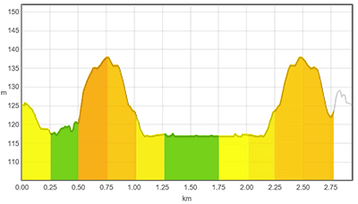
The easy (approximately 2.9 km), blue trail starts from the Häme Nature Centre, and follows one of the nature centre’s own trails, named “Meidän metsä” (Our Forest), from beginning to end. There are signs along the trail, offering information about Finnish nature. The trail is not a traditional circle, but it ends by a lean-to shelter, approximately 1.5 km from the Nature Centre, and returns back along the same route. The trail runs for approximately one kilometre in a Häme forest, until it comes to a lake. You can cross the narrow inlet by a hand-operated ferry. Operating the ferry requires a little effort, and small children should not be left unattended on it. After the ferry, the trail continues for about half a kilometre along duckboards and ends up at a lean-to shelter. The trail’s starting point can be accessed by following the instructions on the DigiTrail app or the signs along the Meidän metsä (Our Forest) path.
Good to know
Other short trails also start from the Häme Nature Centre, and are easy to connect with the route. There is also a beach in the vicinity of the nature centre, open for visitors all year round. The Eerikkilä Sports Institute is not far, either.
Level of difficulty
The easy route takes about one hour. The terrain is easy to walk on, but there are some challenges along the way. You should be careful with the ferries, as the ropes may be slippery and a bit of strength is required to operate the ferry. Regular outdoor equipment and sports shoes are perfect for the trail, as there are hardly any wet or slippery areas. You should, however, be vigilant on the duckboards, especially when it rains.
To the start of the trail
The trail starts from the Häme Nature Centre. The nature centre parking area has plenty of space for vehicles of all sizes, including buses. The starting point is approximately 18 km from Forssa and approximately 15 km from Tammela. The Häme Nature Centre is signposted from Hämeen Härkätie (Ox Road of Häme), number 2824, when arriving from the direction of Porras village. When arriving from Helsinki and Forssa, the Häme Nature Centre is signposted from highway 2. There are various long-haul express buses operating on a daily basis on highway 2 (Helsinki – Pori). You can find bus timetables on Matkahuolto’s website. There is a walk of 1,5 km from the bus stop to the Nature Centre.
TRAIL’S START AND END POINT: Häme Nature Centre, Härkätie 818, 31380 Letku (Tammela) 60.714379, 23.793001
TRAIL MARKINGS: The route is marked with Meidän metsä (Our Forest) signs. In addition, the path is easy to follow using the DigiTrail app.
TRAIL SUITABILITY: The trail is suitable for all hikers, both children and adults.
Theme of the trail: Stop and feel
Trail description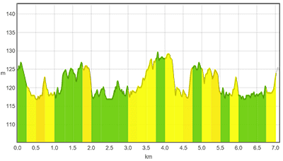
The intermediate (approx. 7.1 km), red route follows the shoreline of Lake Ruostejärvi and the Lynx Trail to Eerikkilä Sports Institute and back. The trail starts from the front of the Nature Centre, leading to a campfire site. Then the path continues for a while along a road and returns back to the forest. The trail leads to the Eerikkilä Sports Institute, which offers a wide range of services. From Eerikkilä, the path returns to the Nature Centre.
Good to know
Other short trails also start from the Häme Nature Centre, and are easy to connect with the intermediate route. There is also a beach in the vicinity of the nature centre, open for visitors all year round. There is one campfire site along the route, and Eerikkilä Sports Institute offers accommodation, meals, and many activities.
Level of difficulty
The intermediate trail takes approximately 3 hours. The terrain consists of a road or a well managed path, and is easy to walk on. The trail’s length makes it challenging. Regular outdoor equipment and sports shoes are perfect for the trail, as there are hardly any wet or slippery areas. You should be careful when walking on the duckboards, especially when it rains.
To the start of the trail
The trail starts from the Häme Nature Centre. The nature centre parking area has plenty of space for vehicles of all sizes, including buses. The starting point is approximately 18 km from Forssa and approximately 15 km from Tammela. The Häme Nature Centre is signposted from Hämeen Härkätie (Ox Road of Häme), number 2824, when arriving from the direction of Porras village. When arriving from Helsinki and Forssa, the Häme Nature Centre is signposted from highway 2. There are various long-haul express buses operating on a daily basis on highway 2 (Helsinki – Pori). You can find bus timetables on Matkahuolto’s website. There is a walk of 1,5 km from the bus stop to the Nature Centre.
TRAIL’S START AND END POINT: Häme Nature Centre, Härkätie 818, 31380 Letku (Tammela) 60.714379, 23.793001
TRAIL MARKINGS: : The route is marked with Meidän metsä (Our Forest) signs. In addition, the path is easy to follow using the DigiTrail app.
TRAIL SUITABILITY: : The route is suitable for slightly more advanced hikers.
Trail description
The difficult (approximately 16.7 km), black trail offers a different perspective on the terrain. The route departs from the Häme Nature Centre and follows the Lynx Trail to Liesjärvi National Park. At the beginning, the trail follows a path and a road alternately. Upon arriving at the National Park, the trail alternately follows a forest road and duckboards. The duckboards lead to the shore of Lake Kaksvetinen, which has a Lapp hut and a campfire site. The trail continues along a path over Numerokalliot (Number Hills), passing the parking area along the way. Soon the trail arrives at another campfire site, continuing thereafter along a path for approximately one kilometer, before joining a sandy road. The road continues all the way to the national park’s border. From there, the trail follows the familiar path back to the trail’s starting point.
Good to know
Other short trails also start from the Häme Nature Centre, and are easy to connect with the route. The trail runs, for the most part, in Liesjärvi National Park, which has various paths criss-crossing. Inside the national park, it is easy to have a longer hike before returning back to the trail’s start. The national park also has connections to the Lynx Trails and the beautiful Kyynäränharju Ridge. It is possible to rent different equipment for the trail from the Häme Nature Centre or local businesses. There is also a beach in the vicinity of the nature centre, open for visitors all year round. Level of difficulty
The easy route takes approximately 5 hours. In practice, the trail follows a path from beginning to end. The paths in Liesjärvi National Park are well-managed and marked. The only places requiring special attention are Numerokalliot (Number Rocks) in the southernmost part of the route. They may be slippery in wet weather. Regular outdoor equipment is ideal for the trail.
To the start of the trail
The trail starts from the Häme Nature Centre. The nature centre parking area has plenty of space for vehicles of all sizes, including buses. The starting point is approximately 18 km from Forssa and approximately 15 km from Tammela. The Häme Nature Centre is signposted from Hämeen Härkätie (Ox Road of Häme), number 2824, when arriving from the direction of Porras village. When arriving from Helsinki and Forssa, the Häme Nature Centre is signposted from highway 2. There are various long-haul express buses operating on a daily basis on highway 2 (Helsinki – Pori). You can find bus timetables on Matkahuolto’s website. There is a walk of 1,5 km from the bus stop to the Nature Centre.
TRAIL’S START AND END POINT: Häme Nature Centre, Härkätie 818, 31380 Letku (Tammela) 60.714379, 23.793001
TRAIL MARKINGS: : The route is marked with Meidän metsä (Our Forest) signs. In addition, the path is easy to follow using the DigiTrail app.
TRAIL SUITABILITY: : The route is suitable for experienced hikers.